
Phoenix Previous-Resident Evidence by Era
A Phoenix address biography works best as a timeline. The current parcel card supplies the modern address, Assessor Parcel Number, legal description, owner, and sometimes a linked deed number. An APN is the county's parcel identifier. The legal description fixes the land by subdivision, lot, block, or survey terms, even when the street address has changed. From that base, each dated record adds one fact about ownership, occupancy, or the building itself.
| Local source | Documented span | Official keeper | Evidence produced |
|---|---|---|---|
| Recorded-document name index | June 1, 1871 to present, split at 1947 | Maricopa County Recorder | Owners, deed parties, recording dates, plats, and probate deeds |
| Assessor and Parcel Viewer | Current and prior-year fields; full history not stated | Maricopa County Assessor | APN, situs, owner, legal description, mapping, and construction year |
| Phoenix directories | Verified scattered titles from 1899 through 1955 | Arizona Memory Project and State Research Library | Named occupants, spouses, work clues, and street addresses |
| Federal census schedules | Released schedules through 1950 | National Archives and genealogy access points | Household members on the enumeration date |
| Phoenix permit search | Online files stated from 1995 to present | Phoenix Planning and Development | Work, applicant, contractor, status, and completion clues |
| Sanborn fire maps | 1889, 1890, 1893, 1901, and a 1915-1949 volume | Library of Congress | Building footprint, material, use, and address continuity |
Start with deeds for former owners and directories or census schedules for previous residents. Those are not the same class of proof. A remote owner may never have lived at the situs address, and an occupant may never appear in the deed chain. Permits and maps explain the property between those human records.
Walk Phoenix Deeds Backward
The Maricopa County Assessor search is the practical starting point because the Recorder index is chiefly name-keyed. Capture the situs, which means the parcel's physical location, then save the APN, current owner, legal description, subdivision or MCR, and linked deed number. An MCR is a Maricopa County Recorder map reference. These identifiers protect the search from same-name owners and altered addresses.
- Find the current parcel and record its owner, APN, legal description, and deed number.
- Open the current owner's purchase deed in the Recorder index. Confirm the same land description, then note the seller, or grantor.
- Search that seller as a buyer, or grantee, in an earlier date range. Match the legal description again.
- Repeat one transfer at a time. Preserve every recording number and date, even when the owner name is a trust or estate.
- Switch to the 1871-1946 search when the trail crosses the 1947 boundary. Docket, book, page, and map references become more important.
- Grantor and grantee
- The grantor transfers an interest; the grantee receives it.
- Chain of title
- The ordered series of recorded transfers affecting the same land.
- Legal description
- The recorded land description that remains useful when a postal address changes.
- Index and image
- The index points to a filing. An image shows the document, while a certified copy is the custodian's authenticated copy.
Recorder results can expose an unofficial page image and purchase routes. Ordinary copies are listed at one dollar per page, with three dollars added per document for certification. The index is a finding aid, not a title opinion. For a complete file or material that the portal does not expose, the Recorder provides online requests, downloadable email or fax forms, and in-person inspection by appointment.
Phoenix Previous Residents Before 1947
The legacy Maricopa recorded-document search states that its name data begins June 1, 1871. It divides searches into 1947-Present and 1871-1946 modes, plus separate research and map paths. That split is a change in search mode, not evidence that older documents were lost. The historical side accepts docket or book, page, party or business name, document code, and dates.
The screen below is the only successful previous-residents capture in the manifest. It illustrates the official bridge between a modern Phoenix parcel and older name-indexed filings.
View the Maricopa County Recorder legacy search used for Phoenix address history.
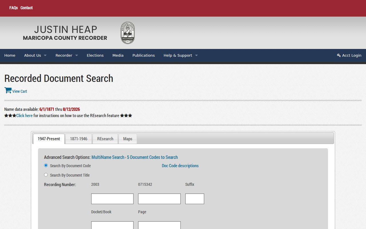
The mode labels matter once a chain reaches 1946. Save the exact docket, book, page, suffix, party spelling, and document code before moving backward again.
Maricopa County's index holds more than 52 million documents, and the Recorder reports about 5,000 new items indexed each day. Its office history also identifies an early local deed: in May 1871, John Roach conveyed the plot now beneath CityScape to William Ford and George Williams for $600. That story shows why land identity, rather than a current building or street label, anchors a long Phoenix trail.
Note: County organization in 1871 does not mean every record series began then or that every surviving image appears online.
Bridge Phoenix's 1893 Street Change
Phoenix replaced north-south street names such as Montezuma and Apache with numbered streets in 1893. A search for previous residents can fail when an old directory, deed, or map uses the former name. Do not force the new address onto the old source. Preserve both forms and compare the legal description, nearby cross streets, plat, MCR, and parcel position.
Annexation adds a second geography problem. Some land now inside Phoenix first appeared in unincorporated Maricopa County or under a rural community label. Pre-1871 trails may also point to predecessor Pima or Yavapai jurisdiction because Maricopa County had not yet been created. A modern “Phoenix” mailing city is not enough to choose the historical custodian.
Keep four identifiers side by side: modern situs, APN, legal description or MCR, and every known historic street form. For full scans, the Library of Congress Sanborn collection can connect numbered and named streets to mapped structures. This geography-first method prevents a false break in the past-resident timeline.
Pair Phoenix Residents With Census
Deeds identify owners, but directories and census schedules supply the household layer. Verified Phoenix city-directory titles include scattered years from 1899-1900 through a 1955 supplement. Some entries name a spouse, work clue, and home address. Telephone or criss-cross sections can support address-first searching, but not every volume contains them. The complete collection details belong on the Phoenix Directory Book page.
- Search the closest available directory year by the known occupant's surname and spelling variants.
- Read that volume's abbreviation key. Transcribe the spouse, home marker, occupation clue, and full address.
- Check an address-first section if the volume has one. Browse page images when optical text recognition misses the name.
- Compare the nearest released federal census schedule. Treat the household as proven only for its enumeration date.
- Use deeds, probate, and obituaries to explain changes between directory and census dates.
The Arizona Memory Project provides free scans and searchable text, though OCR can misread initials, accents, and old type. The loss of most 1890 census schedules makes near-year directories, tax or deed evidence, and newspapers especially valuable. Keep conflicting names visible until another primary record resolves them.
Phoenix Maps Date the Building
Sanborn fire-insurance sheets help determine whether a structure existed during an occupant's era. The Phoenix runs located by the research cover January 1889, November 1890, June 1893, July 1901, and a linked volume spanning 1915 through November 1949. They show footprints, materials, and use. They do not name the residents.
For newer work, the Phoenix project search and permit channels can show project numbers, addresses, issue or completion dates, status, and named applicants or contractors. Online permit research is stated from 1995 forward. A participant on a permit is not proof of occupancy. When an older file or plan is missing online, Planning and Development offers counter, email, and public-record request routes.
This layer can explain why the address shifts from vacant land to a listed household, or why one parcel later holds a different structure. It can also mark renovations between two sets of previous residents without claiming that work date was a move date.
End Phoenix Trails With Probate
A past-resident trail may end with death, inheritance, or a sale by an estate. Search the Recorder for probate deeds, decrees of distribution, death certificates, or trustee documents tied to the legal description. Then use the Maricopa Clerk of Superior Court records channel for the underlying probate file or copy path. Sealed or redacted material remains unavailable.
Obituaries and community archives can supply relationships and later locations, but they are leads. Funeral-home pages may disappear, and family accounts may use nicknames. Arizona State Archives genealogy resources and the State Research Library help bridge older records. The library's staff request service limits a directory search to a three-year window or a newspaper search to two weeks, so arrive with a narrow date range and known spelling variants.
Community-Driven Archives, the Greater Arizona Collection, and local historical manuscripts can restore context that conventional directories missed, especially for South Phoenix and underrepresented communities. Preserve the collection identifier, narrator or creator, and item date. An oral history can explain a block, yet it should not replace a deed, census, or dated directory entry.
Use Phoenix Address History Lawfully
Phoenix previous-residents research supports genealogy, preservation, estate work, and a home's local story. It does not create a right to follow or contact a living person. Arizona law protects qualifying people through the Address Confidentiality Program, voter-record restrictions, and certain county-record address limits. Old public documents may remain while eligible current details are masked.
Record what each source actually proves. A deed marks a recorded land interest. A directory suggests occupancy in its publication year. A census records a household on one day. A permit documents work. None of those facts alone proves where someone lives now.
Lawful use. Use Phoenix address history for respectful personal and historical research. Arizona stalking and harassment laws still apply when a fact came from a public record.