
Trace Phoenix One Street
A Phoenix street directory search can establish a parcel owner, the legal identity of the land, recorded transfers and address-based city activity. It cannot, by itself, prove who sleeps at the address. Start with the exact street form and preserve each identifier as the search moves from one custodian to the next. The assessor is the key bridge because the Recorder is mainly indexed by a person's or entity's name, not by street.
- Enter the full address in the Maricopa County Assessor property search. Record the APN, situs address, current owner, legal description, subdivision or MCR, and linked deed number.
- Open the same parcel in the county map. Select nearby lots to build the street-by-street view without assuming that each owner lives on site.
- Use the owner or deed number in the Recorder index. Match the legal description before treating a deed as part of the same parcel chain.
- Search Phoenix permits, certificates and code cases by address. These files date work and name project participants, but do not create a resident roster.
- For an older household, turn to a directory volume that actually has address-first or criss-cross access, then verify the entry against the volume key.
The Arizona voter self-service portal does not add a public street-browse step. It authenticates the voter with sensitive details. A public voter file is limited by Arizona law to authorized purposes, and protected registrations remain sealed. That boundary is part of an accurate Phoenix address search, not a gap to work around.
Search Phoenix Street Fields
The Assessor accepts several routes into the same Phoenix parcel roll. Its address rules matter. Use a direction such as E, N, W or S, abbreviate the street type, and try the address without the type when a strict search fails. An APN, or assessor parcel number, is the county's book-map-parcel identifier. Separators are optional, and a split suffix may follow the number.
| Search choice | Useful entry | Street-directory purpose |
|---|---|---|
| Parcel number | Book-map-parcel-split | Return to one Phoenix parcel despite a changed address |
| Owner name | Full first and last name | Find parcels held under the same indexed owner |
| Street address | Number, direction, street, short type | Start from a known Phoenix location |
| Subdivision or MCR | Name or Recorder map number | Browse related lots in a recorded plat |
| City or ZIP | City name or five-digit ZIP | Return a broad parcel set for later filtering |
| STR | Section, township and range | Locate land through survey geography |
The official Assessor search instructions show these formats on screen.
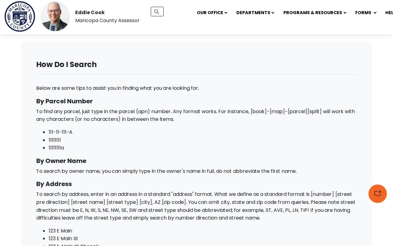
The captured help page confirms why a small format change can recover a Phoenix street result that first looked absent.
Phoenix Street Records Compared
Each official source answers a different part of the street-directory question. The current roll links a Phoenix address to an owner and mailing address. GIS adds shape and jurisdiction. Recorded instruments carry earlier owners. City files add dated events at the site. Historical directories may identify occupants, yet only in the years and formats that survive.
| Address source | Custodian | Street evidence | Channel |
|---|---|---|---|
| Property and tax rolls | Maricopa Assessor and Treasurer | Owner, situs, mailing address, APN, value and tax history | Free web search; Assessor inquiry or counter |
| Parcel map | Maricopa Assessor | Geometry, owner, lot, block, zoning and jurisdiction | Free interactive viewer |
| Deeds and plats | Maricopa Recorder | Transfer parties, date, document number and legal description | Free index/image; online request, form, appointment or paid copy |
| Permits and code cases | City of Phoenix | Project, applicant, contractor, status and dated city action | Web search; department counter or public-record request |
| Old city directories | State Research Library and repositories | Named occupant, spouse, occupation and address in selected years | Digital scan, catalog, staff request or reading room |
| Voter data | Maricopa Recorder | Residence and ZIP only in an authorized public file | Authenticated self-tool or statutory request |
A property situs is the taxable land's physical location. The owner's mailing address can be elsewhere. A plat is a recorded map of lots, blocks and rights of way. A criss-cross directory arranges entries by address rather than only by surname. Keeping those terms separate prevents a Phoenix owner record from being mislabeled as a household list.
- Parcel
- A mapped unit of land identified by the Assessor's APN.
- Situs address
- The physical location of taxable property, distinct from an owner's mailing address.
- Plat
- A recorded map that defines lots, blocks, and rights of way.
- Criss-cross directory
- A directory arranged by address rather than only by a resident's surname.
Map Phoenix Streets by Parcel
The Maricopa County Parcel Viewer converts one address result into a visual street survey. Searchable items include parcel, subdivision, MapID, section, ZIP and personal-property account. A user can select with a point, line, extent, circle, polygon or freehand polygon, then create a result set, add to it or remove lots. The attribute table supports side-by-side review.
Map fields include APN, owner, MCR, subdivision, land size, lot, block, tract, construction year, zoning and jurisdiction. The public GIS layer omits owner mailing address, so click through to the detailed parcel record when that distinction matters. Deep links also accept owner names, subdivision names, MCR numbers and section-township-range strings. Record the map extent and retrieval date because ownership and values change.
For the Phoenix street directory, map selection is strongest when the question concerns a run of parcels. It shows lot boundaries that a postal address can hide, including split or combined land. The viewer caps large selections, so use a tight line or polygon rather than treating a ZIP-wide result as one street.
Note: A map owner label is evidence of the tax roll, not proof that the named person occupies the Phoenix parcel.
Bridge Phoenix Addresses to Deeds
The Assessor's deed number is a useful insider bridge from the address-keyed roll to the name-keyed Maricopa Recorded Document Search. Search by last and first name for a person, or by business name for a trust, company, association or subdivision. Date ranges help with common names. A result can show the indexed party, document kind, recording number, date, page image count and purchase choices.
The legacy Recorder interface separates 1947-present material from the 1871-1946 search and states that name data reaches back to June 1, 1871. Historical work may require docket or book, page, party name, code and date fields. The office reports more than 52 million documents and roughly 5,000 new indexed documents per day, which explains why a broad owner-name query can overwhelm a street search. A deed number and exact legal description reduce that noise.
The Recorder index and unofficial image are finding tools. Copies cost $1 per page, and certification adds $3 per document. If the screen fails, use the Recorder's online county request, downloadable email or fax form, or in-person inspection by appointment at 301 W. Jefferson Street, Suite 200. That fallback keeps a Phoenix street trail moving without guessing at a missing image.
Phoenix Street Tax History
The Maricopa Treasurer parcel search provides another address channel through name, situs, parcel/account number or VIN. Result navigation includes tax summary, tax history, activities, amounts due, receipts, valuations and a detailed statement.
The tax screen adds payment and valuation history, but it still describes the parcel rather than every person at the Phoenix address.
Phoenix Street Project Records
Phoenix Planning and Development adds work history to a street directory. The project search accepts a project number or project name, with wildcards. Results can show the project number, name, total fee and related permits with address, issue date, completion date and status. Details may include inspections, reviewers, decisions, staff dates and notes.
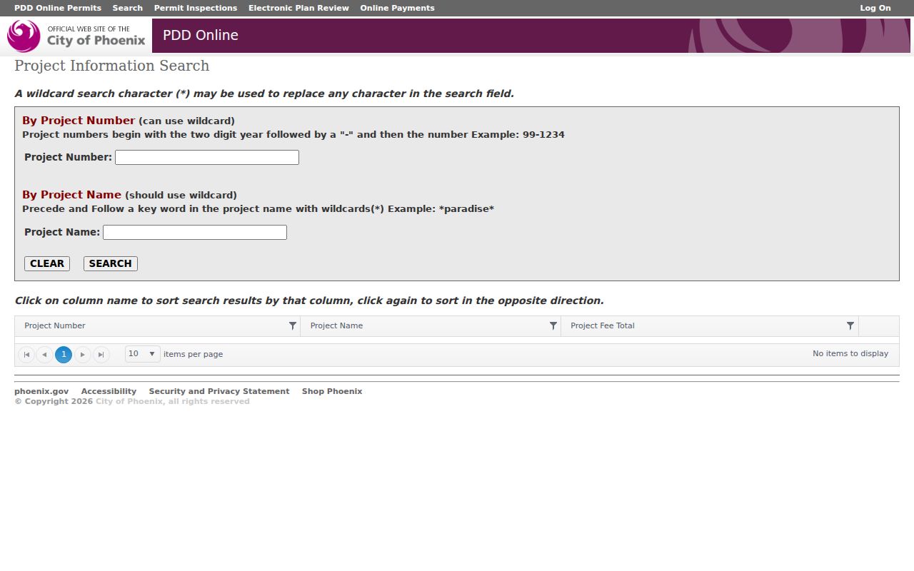
The screen is best used after a Phoenix address search identifies the correct site; a project participant is not necessarily a resident.
Phoenix Street Permit Search
The separate permit search covers online research stated as 1995-present. Planning records also remain available through the second-floor counter at 200 W. Washington Street, by phone at 602-262-7800, or by email at pdd.records@phoenix.gov. The counter can help with approved plans, certificates of occupancy, site and civil files, archived final plans and changes of record.
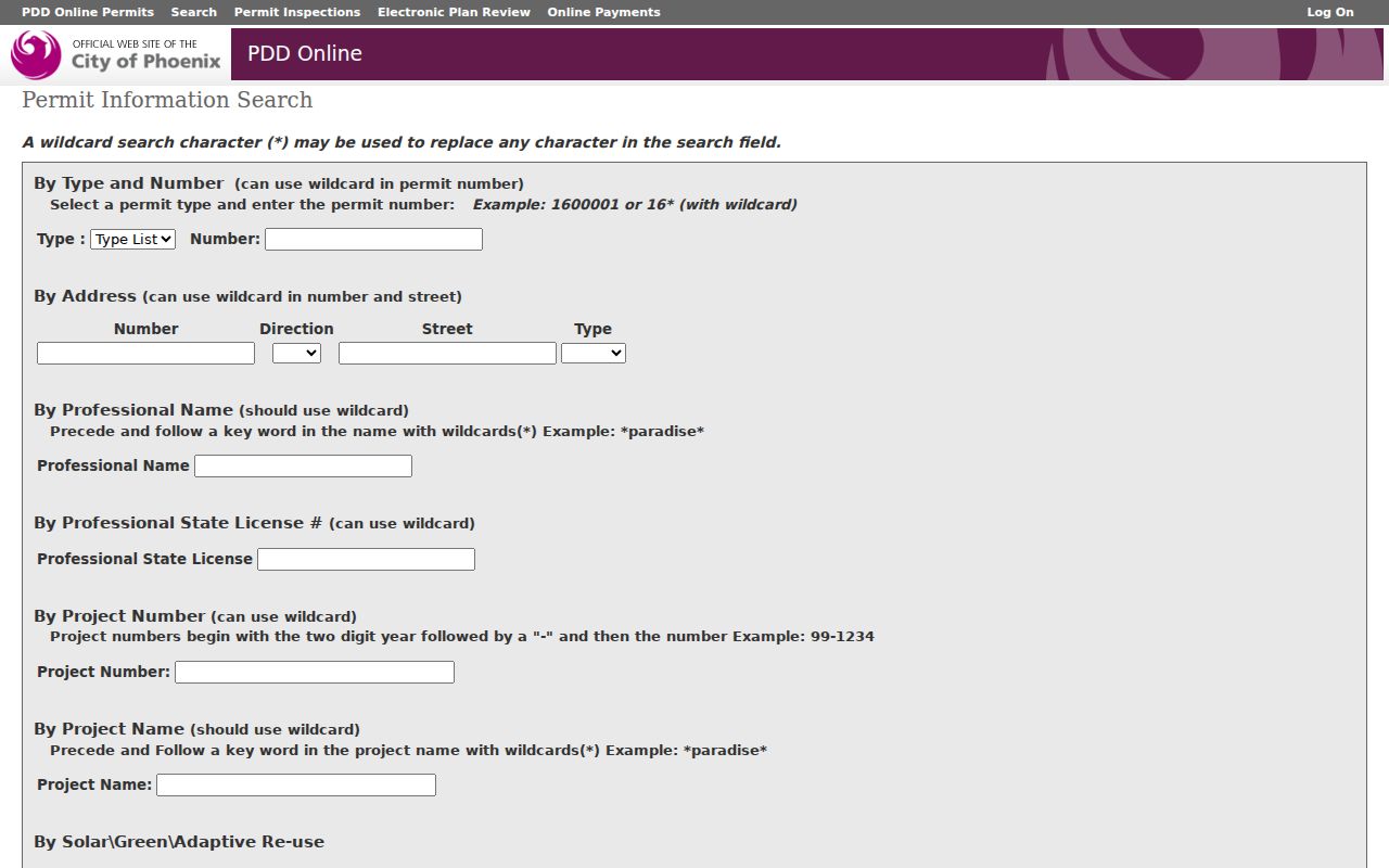
The permit form supplies a dated work trail for the selected Phoenix property without claiming who lived there.
Phoenix Street Code Cases
Neighborhood Services has a distinct code-enforcement status search using a case number or address number, direction and street. A partial street is allowed. The underlying file may require a request and may contain redactions.
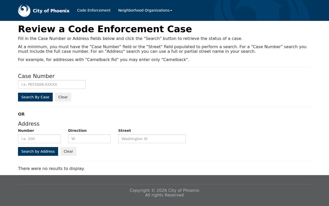
The code result can date a condition or city contact, but it does not identify a complete Phoenix household. New applications moved to SHAPE PHX on April 27, 2026, while legacy projects remain in the older system.
Phoenix Street Names Changed
Phoenix replaced north-south Indigenous-named streets such as Montezuma and Apache with numbered streets in 1893. A street directory search that crosses that year must preserve both names. A directory image, early map and parcel legal description can bridge the change more safely than assuming a modern number matches every old reference.
The modern grid begins at Central Avenue and Washington Street. East and west, north and south designations change there. A hundred block corresponds to each street count: 1st Street is 100 East, 1st Avenue is 100 West, 19th Avenue is 1900 West and 24th Street is 2400 East. Odd addresses generally fall on south or east sides, while even addresses tend to lie on north or west sides.
West numbered routes cycle through Avenue, Drive, Lane, Glen and Dale. East routes use Street, Place, Way, Terrace and Run. Those terms are not interchangeable in an address search. Civil Permits and Addressing can help resolve an official Phoenix address at 602-262-6551 or pdd.cws.permits@phoenix.gov.
Note: Retain the street direction and type with the number, since omitting either can point to a different Phoenix parcel.
Historic Phoenix Street Directory
Old Phoenix city directories may add occupants to a parcel story, but the volumes are not a continuous annual run and not all have an address-first section. Verified Arizona Memory Project holdings include scattered city directories from 1899 through 1955 and telephone volumes from the late 1920s. OCR, or optical character recognition, often misses faded names and unusual type. Browse the alphabetical page when text search fails.
A surviving entry may give a surname, given name or initials, spouse, occupation, employer and a residence mark with an address. A later criss-cross section, when present, reverses the lookup and starts with the street. The full collection, year runs, publishers and reading method belong to the Phoenix historical city directory, while this address workflow uses only the year that fits the parcel question.
If a scan is absent, search the Phoenix Public Library catalog, ask the State Research Library to check a three-year directory window, or visit the Arizona State Archives reading room. The State Research Library may charge when a request exceeds ten copies or scans. These are real access channels, not signs that the Phoenix record did not survive.
Phoenix Street Jurisdiction Shifts
A postal address with “Phoenix” does not prove the parcel lies inside Phoenix city limits. ZIP areas cross municipal lines, and annexation moved many present-day parcels from rural or unincorporated Maricopa County into the city. Parcel Viewer jurisdiction and the legal description should choose the custodian, not neighborhood branding.
Maricopa County began in 1871, while Phoenix incorporated in 1881. A pre-city trail may live in county records, and evidence before county formation can require predecessor jurisdictions. Downtown land may pair a nineteenth-century deed with Sanborn fire maps. Maryvale tends to call for postwar directories, subdivision plats and permits. Far-north parcels can have a long county history before Phoenix annexation.
Canals, freeways, reservation boundaries, mountain preserves and South Mountain interrupt the apparent grid. Arcadia can carry Phoenix or Scottsdale postal ambiguity. The safe sequence is address, parcel jurisdiction, legal description, then custodian. It is the difference between a Phoenix street-directory result and a postal label mistaken for public-record geography.
Phoenix Street Directory Limits
No official Phoenix street search publishes a full list of renters, family members, children, utility subscribers or everyone receiving mail. The assessor names the legal owner. A permit may name an applicant or contractor. A code file can name correspondence parties. None proves day-to-day occupancy. The voter self-tool is not a street roster, and Arizona law restricts public voter files to stated purposes.
Protected records create valid dead ends. Arizona's Address Confidentiality Program provides qualifying survivors with a substitute mailing address and confidential forwarding. Other statutes can restrict some residential addresses in county instruments and voter records. Old public records may remain while eligible details are masked, so an earlier address should never be treated as current without a primary-source check.
Lawful use. Phoenix address records are for lawful personal research, civic inquiry and family or property history. Arizona law prohibits using public details to stalk, harass, intimidate or harm anyone.
Commercial neighbor tools may blend stale public fields with unknown sources. Official rolls are narrower, dated and tied to a custodian, which makes their limits visible. Keep the retrieval date, exact search terms and the distinction between index, unofficial image, ordinary copy and certified copy. That record of method is more useful than forcing uncertain names into a street directory.